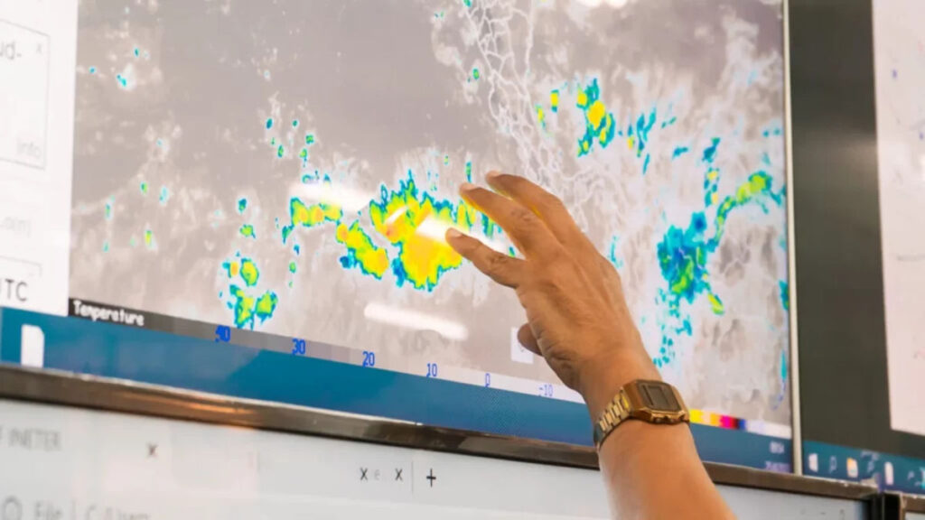


If you’re driving home after Thanksgiving on Sunday, Nov. 29, keep your departure time flexible. The National Weather Service’s latest available outlook, issued Nov. 19, identifies a slight risk of heavy precipitation across much of the Mid-Atlantic and Northeast urban corridor from Friday, Nov. 27, through Sunday, Nov. 29.
Sunday matters because transportation data firm INRIX expects it to be one of the busiest days for return trips. There’s also a separate coastal storm to watch before the holiday. It could bring rain and gusty winds to parts of the East Coast on Sunday, Nov. 22, and Monday, Nov. 23, when some travelers may already be heading out.
The first storm could affect early departures
The National Weather Service office in Mount Holly, New Jersey, expects a low-pressure system to develop off Florida and move north along the coast this weekend. Its early Thursday forecast calls for generally dry conditions through Saturday, Nov. 21, with rain becoming more likely Sunday into Monday. For travelers who can leave a day early, Saturday currently looks like the drier choice in the area.
Advertisement
Advertisement
In its Nov. 19 forecast, the office raised rain probabilities to 40% to 80% from late Sunday into Monday, with the highest chances near the coast. Forecasters are still assessing the storm’s exact track, which will influence how much rain, wind, and coastal flooding the region could experience.
The weather service’s New York office also expects an increasing chance of rain and wind Sunday into Monday. Around Philadelphia, rain, low clouds, and potentially gusty winds could restrict flying conditions. Travelers with early holiday flights should monitor their airline’s updates as the storm approaches.
The holiday forecast now includes Sunday
The National Weather Service’s Climate Prediction Center updated its outlook at 3 p.m. Eastern on Nov. 19. It identified a slight risk of heavy precipitation from Friday, Nov. 27, through Sunday, Nov. 29, across much of the Mid-Atlantic and Northeast urban corridor. The updated forecast maintains Sunday as a potential day for heavy precipitation while narrowing the previously identified risk period.
The outlook identifies a broad area and several days when heavy precipitation is possible. It does not establish which cities will receive the heaviest rain or exactly when conditions could deteriorate. Travelers crossing several states may encounter changing weather along their route.
Advertisement
Advertisement
For a trip along Interstate 95, check forecasts for locations along the highway as well as your starting point and destination. Clear weather at your holiday destination does not guarantee dry roads farther away. Local forecasts will provide more useful guidance for choosing a departure time as Thanksgiving weekend approaches.
Tuesday and Wednesday traffic favors an early start
AAA projects 81.5 million Americans will travel at least 50 miles from home between Nov. 24 and Nov. 30. About 72.9 million are expected to go by car. INRIX expects Tuesday and Wednesday to be the busiest days for people heading out before the holiday.
For Tuesday, Nov. 24, INRIX recommends leaving before 1 p.m. and expects the worst traffic from 2 to 8 p.m. On Wednesday, Nov. 25, it recommends leaving before noon, with the heaviest congestion expected from noon to 7 p.m. Those are local times, and the estimates reflect traffic patterns.
One Mid-Atlantic route to watch is the Baltimore-Washington Parkway. INRIX estimates the northbound trip from Washington to Baltimore could take 1 hour and 53 minutes around 4:30 p.m. Tuesday. That’s more than twice the usual travel time for that route.
Sunday drivers have a window before 11 a.m.
For Sunday, Nov. 29, INRIX recommends getting on the road before 11 a.m. and expects the worst traffic from noon to 8 p.m. If your route is dry in the morning and rain is expected later, an earlier departure could help you avoid both the heavier traffic and the wettest part of the drive.
Advertisement
Advertisement
If the forecast shows heavy rain during that morning window, use local conditions to make the call. Waiting for the rain to let up may make more sense than leaving early to beat traffic. Check for flood alerts and closures before choosing a route or taking a shortcut around a backup.
Travelers who can stay through Monday, Nov. 30, have a second option. INRIX suggests leaving before 1 p.m. Monday, with heavier traffic expected from 2 to 7 p.m. Monday falls outside the current East Coast heavy-precipitation window. Still, the local forecast should guide that decision closer to departure.
State traffic maps show where the drive changes
Virginia plans to lift most lane closures on interstates and other major roads from noon Wednesday, Nov. 25, through noon Monday, Nov. 30. Some long-term work zones will remain in place. The pause could ease some construction bottlenecks, while crashes and weather can still change conditions on the day.
The Virginia Department of Transportation posts live cameras, crash updates, and work zone information through its 511 service. Its Thanksgiving travel map also shows when interstate traffic has historically moved slowest. The map is useful for choosing a departure time, while the live view can help you decide whether to stick with that plan.
Advertisement
Advertisement
New Jersey’s 511 service also shows reported incidents and live highway cameras. If rain is falling when you’re ready to leave, check whether a delay involves a crash, flooding, or a closed lane before switching routes. The National Weather Service advises drivers to turn around if they reach a flooded road or a barricade.
Flyers should check the whole itinerary
Start with your airline’s app or website for updates on your flight. The Federal Aviation Administration’s National Airspace System Status page can show broader airport problems, such as a ground delay. An airport-wide notice gives you context, while the airline can tell you what’s happening with your booking.
Source: ibphoto/Depositphotos
If you’re connecting, add the middle airport to your weather check. You may have clear skies at both ends of the trip, while rain or wind can slow flights at the connecting airport. If the airline issues a weather waiver, check which airports and travel dates it covers before changing your ticket.
The U.S. Department of Transportation says passengers are entitled to a refund if their airline cancels a flight and they decline the alternative arrangements offered.
Advertisement
Advertisement
Refund eligibility also applies to certain significant schedule changes, including domestic flights arriving at least 3 hours later than originally scheduled, when passengers decline the changed itinerary and other compensation. Check your options before accepting a voucher if you’d prefer a refund.
Little-known fact: The National Weather Service says just 12 inches of water can float a car or small SUV.
TL;DR
The latest outlook flags a slight risk of heavy precipitation across much of the Mid-Atlantic and Northeast from Friday, Nov. 27, through Sunday, Nov. 29.
A separate coastal storm could bring rain and gusty winds to parts of the East Coast on Nov. 22 and 23.
INRIX recommends Sunday return drivers leave before 11 a.m. if local weather allows.
For the trip out, INRIX favors Tuesday before 1 p.m. or Wednesday before noon.
Check road conditions along your full route and monitor all airports on your itinerary if you have a connecting flight.
This article was made with AI assistance and human editing.
If you liked this, you might also like:
Advertisement
Advertisement
The post Potential East Coast storms could disrupt Thanksgiving travel appeared first on When In Your State.
Source link